Introduction to Aviation Navigation
Aviation navigation encompasses the methods, systems, and procedures that enable aircraft to travel safely from one location to another through three-dimensional airspace. It represents one of humanity's most sophisticated navigation disciplines, combining ancient principles with cutting-edge technology to overcome the unique challenges of flight.
Unlike surface-based navigation, aviation requires precise positioning in three dimensions, operates at much higher speeds, traverses environments with few visual references, and faces critical fuel and weather constraints. These factors have driven the development of specialized navigation systems that have evolved from basic visual techniques to today's satellite-based precision approaches.
The Evolution of Aviation Navigation
- Early Days (1900s-1920s): Pilots relied primarily on visual landmarks, railroad tracks, and rivers for navigation
- Airways Era (1920s-1940s): Development of lighted airways, radio range stations, and basic radio communications
- Radio Navigation (1940s-1970s): Widespread adoption of VOR, NDB, and ILS systems for all-weather operations
- Inertial Systems (1960s-1990s): Self-contained navigation without external references for long-range flight
- Satellite Revolution (1990s-present): GPS and other GNSS systems providing global coverage with unprecedented accuracy
- Performance-Based Era (Current): Emphasis on required navigation performance rather than specific equipment
Today's aviation navigation represents a sophisticated blend of these technologies, with multiple redundant systems ensuring safety even when individual components fail. This comprehensive guide explores the principles, systems, and procedures that enable everything from small training aircraft to intercontinental airliners to navigate safely and efficiently through the skies.
Aviation Navigation Fundamentals
Understanding aviation navigation begins with several fundamental concepts that form the basis for all navigation methods used in flight.
The Earth and Aviation Coordinates
- Latitude and Longitude: The global reference system using degrees, minutes, and seconds (or decimal minutes) to specify any position on Earth.
- Great Circle Routes: The shortest path between two points on the Earth's surface, forming the basis for long-distance flight planning.
- Magnetic vs. True North: The critical distinction between the geographic North Pole and the magnetic North Pole, with variation changing based on location and time.
- Nautical Mile: The standard unit of distance in aviation, equal to one minute of latitude (approximately 1.15 statute miles or 1.85 kilometers).
Three-Dimensional Navigation
- Altitude Measurement:
- Mean Sea Level (MSL): Height above average sea level, used for terrain clearance
- Above Ground Level (AGL): Height directly above terrain
- Flight Level (FL): Pressure altitude in hundreds of feet, used above transition altitude
- Vertical Navigation: Managing climbs, descents, and level flight with consideration for terrain, airspace, and aircraft performance.
- Atmospheric Considerations: Effects of pressure and temperature on altimeter readings and aircraft performance.
Directional References
- Heading: The direction the aircraft is pointing.
- Course: The intended path over the ground.
- Track: The actual path over the ground (may differ from heading due to wind).
- Bearing: The direction from the aircraft to a point of interest.
- Radial: The direction from a navigation aid to the aircraft.
Speed Measurements
- Airspeed:
- Indicated Airspeed (IAS): Direct instrument reading
- Calibrated Airspeed (CAS): IAS corrected for instrument and position errors
- True Airspeed (TAS): CAS corrected for altitude and temperature, representing actual speed through air mass
- Groundspeed: Actual speed over the ground, accounting for wind effects.
- Mach Number: Ratio of TAS to the speed of sound, used at high altitudes.
Wind Effects
- Wind Triangle: The vector relationship between heading, track, and wind.
- Drift Correction: Adjusting heading to maintain desired course in the presence of crosswind.
- Headwind/Tailwind Component: Effect on groundspeed and fuel consumption.
- Wind Correction Angle (WCA): The angle between heading and track required to counter wind drift.

Understanding fundamental navigation concepts is essential before advancing to specific navigation techniques
Visual Flight Navigation
Visual Flight Rules (VFR) navigation involves piloting an aircraft primarily by visual reference to the environment, using landmarks, terrain features, and other visual cues to determine position and maintain course.
Pilotage
The most fundamental form of aviation navigation, pilotage involves identifying landmarks on the ground and correlating them with their representation on aeronautical charts:
- Checkpoint Selection: Choosing distinctive, unmistakable features visible from altitude (lakes, towns, mountain peaks, etc.).
- Feature Recognition: Developing the ability to identify landscape elements from an aerial perspective.
- Chart Correlation: Matching observed features with their cartographic representation.
- Progressive Position Fixing: Continuously updating position awareness as landmarks are overflown.
Dead Reckoning
Calculating current position based on known previous position, course, speed, and elapsed time:
- Flight Planning: Pre-calculating expected positions at specific times.
- Track Maintenance: Using heading, time, and distance to follow planned route.
- Position Updates: Periodically correcting dead reckoning with visual fixes.
- Wind Estimation: Observing drift to determine actual wind conditions.
Basic VFR Navigation Process
- Plan route using appropriate VFR charts and forecast weather
- Calculate headings, groundspeeds, and estimated times between checkpoints
- Apply wind correction to determine proper heading to maintain desired track
- During flight, identify checkpoints visually and verify position
- Cross-check actual versus planned groundspeed and time estimates
- Update calculations as needed based on observed conditions
- Maintain situational awareness regarding airspace, terrain, and alternate airports
Visual Navigation Aids
- Sectional Charts: Detailed aeronautical charts specifically designed for visual navigation.
- Airport/Facility Directory: Comprehensive information about airports and navigation facilities.
- Visual Landmarks: Distinctive terrain features, infrastructure, and human-made objects.
- Flight Computer: Manual or electronic device for navigation calculations.
- Plotter: Tool for measuring distances and courses on aeronautical charts.
VFR Navigation Challenges
- Reduced Visibility: Haze, precipitation, smoke, or cloud conditions limiting visual reference.
- Featureless Terrain: Areas with few distinctive landmarks (oceans, deserts, uniform forests).
- Lighting Conditions: Sun glare, shadows, and low light affecting feature recognition.
- Chart Currency: Ensuring charts reflect current landscape features and airspace.
- Pilot Workload: Balancing navigation tasks with aircraft control and communications.
VFR Navigation Safety Considerations
- Always maintain minimum required visibility and cloud clearance for VFR flight
- Plan conservatively for fuel requirements, including reserves for unexpected conditions
- Establish specific diversion criteria before flight (weather minimums, timing, etc.)
- Maintain awareness of Minimum Safe Altitudes (MSAs) for terrain clearance
- Consider GPS or other navigation aids as backup to visual navigation
Instrument Flight Navigation
Instrument Flight Rules (IFR) navigation allows pilots to fly in conditions with limited or no outside visual references by relying on aircraft instruments and external navigation systems.
Basic Instrument Navigation
The fundamental instruments and concepts for position awareness without visual references:
- Attitude Indicator: Shows aircraft orientation relative to the horizon.
- Heading Indicator/Directional Gyro: Displays aircraft heading.
- Altimeter: Indicates aircraft altitude based on atmospheric pressure.
- Vertical Speed Indicator: Shows rate of climb or descent.
- Turn Coordinator: Displays rate of turn and coordination.
- Airspeed Indicator: Shows aircraft speed through the air mass.
Navigation Instruments
Specialized instruments for determining position and course:
- Course Deviation Indicator (CDI): Shows position relative to a selected course.
- Radio Magnetic Indicator (RMI): Displays magnetic heading and bearing to selected stations.
- Distance Measuring Equipment (DME): Shows slant range distance to a DME ground station.
- Automatic Direction Finder (ADF): Points to NDB stations for bearing information.
- Horizontal Situation Indicator (HSI): Combines heading indicator with navigation display.
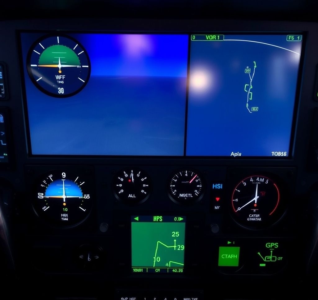
Modern glass cockpit displays integrate multiple navigation systems into easily interpretable formats
Glass Cockpit Systems
Modern integrated flight deck displays that consolidate multiple instruments and systems:
- Primary Flight Display (PFD): Shows critical flight parameters including attitude, airspeed, altitude, and navigation information.
- Multi-Function Display (MFD): Provides supplementary information including moving maps, weather, traffic, and system status.
- Engine Indicating and Crew Alerting System (EICAS): Monitors engine parameters and system alerts.
- Flight Management System (FMS): Integrated navigation computer for route planning and execution.
- Synthetic Vision: Computer-generated terrain imagery providing visual reference in low visibility.
Instrument Approach Procedures
Standardized procedures for navigating to and landing at airports in instrument conditions:
- Precision Approaches: Provide both lateral and vertical guidance (ILS, GLS, etc.).
- Non-Precision Approaches: Provide lateral guidance only (VOR, NDB, RNAV, etc.).
- Approach Segments: Initial, intermediate, final, and missed approach segments with specific navigation criteria.
- Decision Height/Minimum Descent Altitude: Lowest altitude for continuing approach without visual reference.
- Approach Lighting Systems: Ground-based visual aids for transitioning from instrument to visual references.
IFR Navigation Tips
- Maintain instrument proficiency through regular practice, even in good weather
- Use "bracketing" technique when intercepting courses (turn more than needed, then back to course)
- Cross-check multiple navigation sources to verify position
- Brief approach procedures thoroughly before execution
- Maintain "instrument scan" to avoid fixation on any single instrument
Radio Navigation Systems
Radio-based navigation systems form the backbone of conventional aviation navigation infrastructure, providing standardized, reliable positioning information through a network of ground-based transmitters and airborne receivers.
VHF Omnidirectional Range (VOR)
The primary radio navigation system for decades, providing directional information:
- Operating Principle: Ground station transmits signals that allow aircraft to determine their bearing from the station.
- Radials: 360 courses oriented outward from the station like spokes on a wheel.
- Course Selection: Pilot selects desired radial for navigation to or from the station.
- Range: Typically usable to about 130 nautical miles at higher altitudes.
- Limitations: Line-of-sight signal propagation, terrain effects, limited coverage at low altitudes.
Non-Directional Beacon (NDB)
One of the oldest aviation navigation aids, still in use in some regions:
- Operating Principle: Omnidirectional radio transmitter broadcasting on medium frequency.
- Automatic Direction Finder (ADF): Airborne receiver that points to the station, regardless of aircraft heading.
- Advantages: Longer range than VOR, less affected by terrain, usable at lower altitudes.
- Limitations: Susceptible to thunderstorm static, nighttime propagation changes, and interference.
- Applications: Remote area navigation, oceanic entry/exit points, holding patterns, non-precision approaches.
Distance Measuring Equipment (DME)
- Operating Principle: Aircraft interrogates ground station, which replies; time difference determines distance.
- Measurement: Provides slant range distance (direct line from aircraft to station, not ground distance).
- Co-location: Often paired with VORs (VOR/DME) or ILS systems for combined bearing and distance.
- Applications: Position fixing, distance to go, groundspeed calculation, arc interceptions.
- Limitations: Accuracy decreases with distance, maximum number of simultaneous users.
Instrument Landing System (ILS)
Precision approach system providing both lateral and vertical guidance to runway:
- Components:
- Localizer: Provides horizontal guidance along runway centerline
- Glide Slope: Provides vertical guidance along optimal descent path
- Marker Beacons or DME: Indicate distance from runway threshold
- Categories: Different ILS installations certified for varying minimum visibility conditions (CAT I, II, III).
- Precision: Highly accurate guidance to decision height as low as 200 feet (CAT I) or to touchdown (CAT III).
- Limitations: Affected by terrain, structures, and large aircraft; requires extensive ground installation.
Comparison of Radio Navigation Systems
| System | Frequency Band | Information Provided | Typical Range | Primary Applications |
|---|---|---|---|---|
| VOR | VHF (108-117.95 MHz) | Magnetic bearing | 130 NM | Airways, approaches, position fixing |
| NDB | LF/MF (190-535 kHz) | Relative bearing | 50-300 NM | Remote areas, oceanic, approaches |
| DME | UHF (962-1213 MHz) | Slant range distance | 199 NM | Distance measurement, arcs, approaches |
| ILS Localizer | VHF (108-111.95 MHz) | Lateral guidance | 18-25 NM | Precision approaches |
| ILS Glide Slope | UHF (329-335 MHz) | Vertical guidance | 10 NM | Precision approaches |
Other Radio Navigation Systems
- Tactical Air Navigation (TACAN): Military system combining VOR and DME functions with greater accuracy.
- VHF Direction Finding (VDF): Ground-based service that can provide bearing to aircraft transmitting on VHF.
- Marker Beacons: Fixed-position transmitters indicating specific points along an approach path.
- Microwave Landing System (MLS): Advanced approach system offering flexible approach paths (largely replaced by satellite-based approaches).
Satellite-Based Navigation
Global Navigation Satellite Systems (GNSS) have revolutionized aviation navigation by providing accurate, global positioning without reliance on ground-based infrastructure.
Global Positioning System (GPS)
The U.S.-operated satellite constellation forming the most widely used GNSS:
- Operating Principle: Triangulation of time signals from multiple satellites to determine precise position.
- Coverage: Global, 24-hour availability with sufficient satellites for redundancy.
- Accuracy: Approximately 3-15 meters for standard receivers; enhanced by augmentation systems.
- Aviation Applications: En route navigation, approaches, airport surface navigation, search and rescue.
- Integrity Monitoring: Receiver Autonomous Integrity Monitoring (RAIM) to detect satellite errors.
Other Global Navigation Satellite Systems
- GLONASS: Russian satellite constellation providing global coverage.
- Galileo: European Union's satellite system offering high-precision civilian service.
- BeiDou: Chinese navigation system providing global positioning.
- Multi-Constellation Receivers: Modern aviation GPS units often utilize multiple GNSS systems for improved accuracy and redundancy.

GNSS systems provide global positioning coverage through constellations of orbiting satellites
Augmentation Systems
Systems that enhance the performance of basic GNSS:
- Wide Area Augmentation System (WAAS): U.S. system providing GPS corrections for improved accuracy and integrity monitoring.
- European Geostationary Navigation Overlay Service (EGNOS): European equivalent to WAAS.
- Multi-functional Satellite Augmentation System (MSAS): Japanese augmentation system.
- Ground-Based Augmentation System (GBAS): Local area augmentation providing precision approach capability.
- Satellite-Based Augmentation System (SBAS): General term for systems like WAAS, EGNOS, and MSAS.
GNSS Approaches
- RNAV (GPS) Approaches: Non-precision approaches using basic GPS guidance.
- LPV (Localizer Performance with Vertical guidance): Approaches with precision-like vertical guidance using WAAS.
- GLS (GNSS Landing System): Precision approaches using GBAS (similar capability to ILS).
- RNP AR (Required Navigation Performance Authorization Required): High-precision approaches requiring special aircraft capability and crew training.
GNSS Limitations and Vulnerabilities
- Signal jamming or interference can disrupt service over large areas
- Solar activity can affect signal propagation and accuracy
- Satellite constellation issues or system-wide failures are possible
- Local obstructions (terrain, buildings) can block satellite signals
- Most aviation operations require backup navigation systems independent of GNSS
Aeronautical Charts and Publications
Specialized maps and documentation designed specifically for aviation navigation, providing critical information for flight planning and execution.
Visual Flight Rules (VFR) Charts
- Sectional Charts: Detailed charts for visual navigation with comprehensive aeronautical and topographic information.
- Terminal Area Charts (TAC): More detailed versions of sectional charts covering busy terminal areas.
- World Aeronautical Charts (WAC): Smaller scale charts for long-distance visual flight planning.
- VFR Flyway Planning Charts: Simplified charts showing recommended VFR routes through complex airspace.
- Helicopter Route Charts: Specialized charts showing helicopter routes and facilities in urban areas.
Instrument Flight Rules (IFR) Charts
- Enroute Low/High Altitude Charts: Display airways, intersections, navigation aids, and airspace for IFR navigation.
- Area Charts: Detailed charts for complex terminal areas.
- Standard Terminal Arrival Routes (STARs): Charted arrival procedures from en route phase to approach.
- Standard Instrument Departures (SIDs): Charted departure procedures from takeoff to en route phase.
- Instrument Approach Procedure (IAP) Charts: Detailed charts for executing instrument approaches.

Aeronautical charts contain specialized symbology and information critical for safe navigation
Chart Elements and Symbology
- Terrain Representation: Elevation contours, spot heights, terrain coloring, and obstacle information.
- Airspace Classifications: Visual depiction of different airspace types and their boundaries.
- Navigation Aids: Symbols for VORs, NDBs, ILS facilities, and other navigation systems.
- Airports: Detailed information about runways, frequencies, services, and restrictions.
- Airways and Routes: Designated paths for IFR flights with navigation specifications.
- Communication Frequencies: Information for contacting air traffic control and other services.
- Special Use Airspace: Restricted, prohibited, warning, and alert areas.
Electronic Flight Bags (EFBs) and Digital Charts
- Digital Chart Formats: Electronic versions of paper charts with enhanced functionality.
- Moving Map Displays: GPS-integrated chart displays showing aircraft position in real-time.
- Chart Overlays: Weather, traffic, terrain, and other information displayed on charts.
- Electronic Flight Bag Systems: Tablet or installed devices replacing paper charts and documentation.
- Chart Currency Management: Automated updates ensuring latest information is available.
Critical Publications
- Airport/Facility Directory (A/FD): Detailed airport data including services, runways, and operational information.
- Notices to Airmen (NOTAMs): Time-critical information not yet included on published charts.
- Chart Supplements: Additional information supplementing aeronautical charts.
- International Flight Information Manual (IFIM): Information for international operations.
- Aeronautical Information Publications (AIPs): Comprehensive aviation information for specific countries.
Chart Reading Tips
- Check chart currency dates before each flight
- Review chart legends to understand specific symbology
- Pay special attention to chart notes and warnings
- Cross-reference charts with text-based publications for complete information
- Highlight critical information relevant to your specific flight
Flight Planning and Navigation
The process of planning and executing the navigation component of flights involves integrating various factors to ensure safe, efficient, and legal operations.
Route Planning
- Route Selection Factors:
- Terrain and obstacle clearance
- Airspace restrictions
- Weather conditions
- Aircraft performance capabilities
- Fuel efficiency
- Available navigation aids
- Traffic flow constraints
- VFR Route Planning: Selecting visual checkpoints, appropriate altitudes, and alternate airports.
- IFR Route Planning: Determining airways, fixes, SIDS/STARS, and approach procedures.
- Direct Routing: Utilizing RNAV capabilities for more efficient point-to-point navigation.
- Flight Plan Filing: Documenting intended route for air traffic control and search/rescue purposes.
Navigation Calculations
- Time, Speed, and Distance: Basic calculations of time en route between waypoints.
- Fuel Planning: Calculating fuel requirements based on distance, winds, and contingencies.
- Wind Correction: Determining heading adjustments to maintain desired ground track.
- Climb/Descent Planning: Calculating top of descent points and vertical speed requirements.
- Weight and Balance: Ensuring aircraft loading remains within limits throughout flight.
Basic Wind Correction Calculation
- Determine desired course from chart (e.g., 090°)
- Obtain wind direction and speed from forecast (e.g., 030° at 20 knots)
- Calculate wind correction angle (e.g., +8° for this example)
- Apply correction to heading (090° + 8° = 098°)
- Calculate groundspeed based on true airspeed and wind component
- Determine estimated time en route based on distance and groundspeed
Flight Planning Tools
- Manual Flight Computer: Specialized circular slide rule for aviation calculations.
- Electronic Flight Planning Software: Computer programs for comprehensive flight planning.
- Flight Management Systems (FMS): Onboard computers for route planning and execution.
- Web-Based Planning Services: Online tools providing route optimization and documentation.
- Navigation Logs: Structured forms for recording navigation data and tracking progress.
Flight Plan Execution
- Cockpit Organization: Arranging charts and materials for efficient access during flight.
- Position Tracking: Continuously monitoring aircraft position relative to planned route.
- Checkpoint Discipline: Systematically verifying position at predetermined points.
- Course Corrections: Making heading adjustments based on observed tracking errors.
- Diversion Management: Replanning routes when original plan becomes unfeasible.
Flight Planning Considerations
- Always plan for worse conditions than forecast
- Include adequate fuel reserves for unexpected events
- Identify decision points for potential diversions
- Consider aircraft performance degradation factors (icing, turbulence)
- Verify NOTAM information for navigation aid outages or restrictions
Weather and Navigation
Weather significantly impacts aviation navigation decisions, techniques, and safety. Understanding these interactions is critical for effective flight planning and execution.
Weather Effects on Navigation
- Visibility Reduction: Fog, precipitation, haze, and smoke limiting visual reference points.
- Cloud Obstruction: Clouds blocking ground references and creating spatial disorientation hazards.
- Wind Effects: Crosswinds requiring heading corrections and headwinds/tailwinds affecting groundspeed.
- Turbulence: Rough air making instrument reading and chart handling more difficult.
- Icing: Accumulation affecting instrument sensors and aircraft performance.
- Thunderstorms: Requiring course deviations and creating navigation system interference.
Weather Navigation Planning
- Pre-flight Weather Analysis: Comprehensive assessment of en route and destination conditions.
- Alternative Route Planning: Identifying weather-friendly routing options.
- Strategic Altitude Selection: Choosing cruise altitudes that minimize adverse weather exposure.
- Timing Considerations: Scheduling departures to avoid forecast adverse conditions.
- Fuel Planning: Adding reserves for weather deviations and holding.
Weather information integration is critical for safe navigation planning and execution
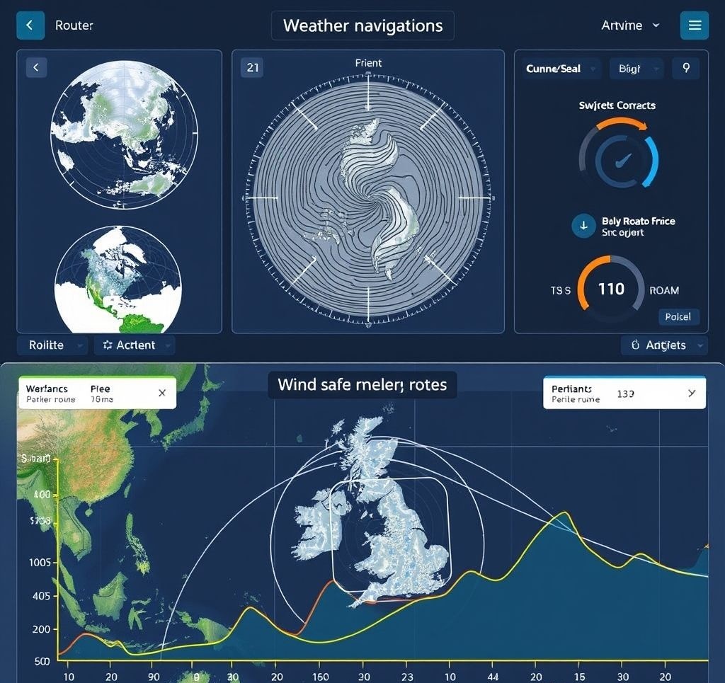
Weather Navigation Systems
- Airborne Weather Radar: Onboard system detecting precipitation intensity for tactical avoidance.
- Lightning Detection: Systems identifying thunderstorm activity through electrical discharge detection.
- Datalink Weather: Satellite-delivered weather information displayed in the cockpit.
- Enhanced Vision Systems: Infrared cameras improving visibility in certain conditions.
- Weather Information Integration: Display systems combining multiple weather data sources with navigation information.
Tactical Weather Navigation
- Thunderstorm Avoidance: Techniques for safely navigating around convective activity.
- Frontal Penetration: Optimal methods for crossing weather fronts when necessary.
- Terrain/Weather Interactions: Understanding how mountains and terrain affect weather patterns.
- Icing Management: Navigation strategies to minimize exposure to icing conditions.
- Diversion Decision-Making: Criteria for determining when weather requires course or destination changes.
Weather Navigation Tips
- Obtain multiple weather data sources for more complete picture
- Consider seasonal and diurnal weather patterns in planning
- Understand weather radar limitations (beam attenuation, tilt considerations)
- Maintain heightened position awareness during adverse weather
- Establish personal weather minimums more conservative than regulatory requirements
Emergency Navigation Procedures
When navigation systems fail or emergency conditions develop, pilots must rely on alternative methods to determine position and reach safety.
Navigation System Failures
- Primary Navigation System Failure: Procedures for transitioning to secondary or backup systems.
- Complete Avionics Failure: Navigation techniques when all electronic systems are unavailable.
- Partial Panel Operations: Navigation with limited instrument functionality.
- GPS Signal Loss/Degradation: Alternative methods when satellite navigation becomes unreliable.
- Navigation Database Issues: Procedures for handling incorrect or corrupted navigation data.
Emergency Position Determination
- Radar Services: Requesting position information from air traffic control.
- Direction Finding Services: Ground-based facilities determining aircraft bearing.
- Pilotage Reversion: Using visual references when instrument systems fail.
- Triangulation Techniques: Using multiple bearings to establish position.
- Emergency Locator Transmitter (ELT): Automatic or manual activation for search and rescue positioning.
Lost Procedures
Steps to follow when position is uncertain:
- Confess: Acknowledge the situation and notify ATC if possible.
- Climb: Gain altitude for better visibility, radio reception, and terrain clearance.
- Communicate: Request assistance from any available source.
- Conserve: Reduce fuel consumption while working to establish position.
- Comply: Follow ATC instructions or emergency protocols.
Navigation in Adverse Conditions
- Severe Weather Avoidance: Navigation techniques for circumnavigating dangerous weather.
- Low Visibility Procedures: Methods for maintaining position awareness in degraded visual conditions.
- Navigation System Interference: Handling situations where systems experience external disruption.
- Terrain Avoidance: Emergency procedures when proximity to terrain is detected.
Emergency Navigation Essentials
- Always maintain awareness of nearest suitable airports
- Carry appropriate backup navigation resources (charts, handheld GPS)
- Practice partial panel and lost procedures regularly
- Know how to access emergency frequencies (121.5 MHz)
- Understand terrain features along your route for emergency reference
Future Navigation Systems and Developments
Aviation navigation continues to evolve with emerging technologies and concepts designed to enhance safety, efficiency, and capacity.
NextGen and SESAR
Major modernization initiatives in the U.S. and Europe transforming air traffic management:
- Automatic Dependent Surveillance-Broadcast (ADS-B): Aircraft broadcasting precise position information derived from GNSS.
- System Wide Information Management (SWIM): Integrated approach to sharing aviation information among stakeholders.
- Data Communications (DataComm): Digital communication replacing voice for many ATC functions.
- Performance-Based Navigation (PBN): Continued expansion of RNAV and RNP operations.
- Trajectory-Based Operations (TBO): Managing flights based on precise four-dimensional paths.
Advanced Navigation Concepts
- Time-Based Metering: Managing traffic flow through precise timing rather than distance spacing.
- Alternative Position, Navigation, and Timing (APNT): Systems providing backup to GNSS for resilient navigation.
- Ground-Based Augmentation System (GBAS) Expansion: Enhanced precision approach capability at more airports.
- Advanced RNP Procedures: More sophisticated paths optimizing airspace and airport access.
- Multi-Constellation GNSS Receivers: Integration of all available satellite navigation systems.
Emerging Technologies
- Synthetic Vision Systems: Computer-generated terrain displays providing visual reference regardless of outside conditions.
- Combined Vision Systems: Integration of synthetic vision with enhanced vision (infrared) technology.
- Augmented Reality: Overlay of navigation information on visual field through head-up or wearable displays.
- Advanced Decision Support Tools: Systems providing pilots with optimized routing and tactical guidance.
- Quantum Positioning Systems: Emerging technology using quantum principles for navigation without external references.

Future navigation systems integrate multiple data sources with advanced visualization techniques
Unmanned Aircraft Systems (UAS) Navigation
- Detect and Avoid Systems: Technologies enabling UAS to navigate safely among other aircraft.
- UTM (UAS Traffic Management): Specialized systems for managing low-altitude drone operations.
- Autonomous Navigation: Advanced systems allowing operation without human input.
- Remote ID: Electronic identification systems for UAS tracking and accountability.
- Non-Traditional Navigation Sensors: Computer vision, LIDAR, and other sensing technologies.
Integration Challenges
- Mixed Equipage Operations: Managing airspace with aircraft of varying navigation capabilities.
- Cybersecurity: Protecting increasingly digital navigation systems from interference or attack.
- Training Evolution: Developing pilot skills for advanced navigation technologies.
- Certification Standards: Creating appropriate requirements for new navigation systems.
- Global Harmonization: Aligning navigation standards across international boundaries.
Preparing for Navigation Evolution
- Stay informed about equipage requirements and deadlines
- Maintain proficiency in fundamental navigation skills regardless of automation
- Participate in industry forums and training addressing new technologies
- Consider upgrade paths that align with long-term navigation roadmaps
- Approach new technology with both enthusiasm and healthy skepticism
Conclusion: The Art and Science of Aviation Navigation
Aviation navigation represents a remarkable blend of ancient principles and cutting-edge technology, constantly evolving yet still rooted in fundamental concepts that have guided pilots for generations. From the earliest aviators following railroad tracks to today's pilots executing satellite-guided approaches in zero visibility, the core mission remains unchanged: safely guiding aircraft from departure to destination.
The most effective approach to aviation navigation combines technological reliance with fundamental skill mastery. Modern pilots must be equally comfortable programming complex flight management systems and reverting to basic navigation techniques when those systems fail. This layered competency ensures resilience in the face of unexpected challenges and maintains the remarkable safety record of modern aviation.
As technology continues to advance, the human role in aviation navigation is evolving rather than diminishing. Pilots are becoming increasingly sophisticated system managers, blending automation oversight with traditional airmanship to optimize safety and efficiency. This synergy between human judgment and technological capability represents the future of aviation navigation.
Whether you're an aviation professional, a student pilot, or simply fascinated by how aircraft navigate the skies, understanding these principles provides valuable insight into one of humanity's most impressive technical achievements—the ability to precisely guide aircraft across vast distances through the three-dimensional realm of flight.